Re: 40 Stunning Images Of Our Planet By NASA
Posted: Tue Jan 30, 2018 12:55 pm
13. Exploring the World’s Protected Areas from Space
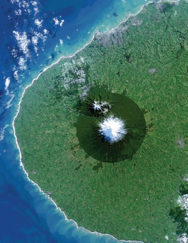
A new book released this week highlights how the view from space with Earth-orbiting sensors is being used to protect some of the world’s most interesting, changing, and threatened places. From space, Egmont National Park in New Zealand shows the benefits and limitations of protected areas. In this Landsat 8 image acquired on July 3, 2014, the park, with Mt. Taranaki at its center, was established in 1900. This isolated island of protected forest (dark green areas) is surrounded by once-forested pasturelands (light and brown green).
“Sanctuary: Exploring the World’s Protected Areas from Space,” published by the Institute for Global Environmental Strategies (Arlington, Virginia) with support from NASA, debuted at the 2014 World Parks Congress in Sydney, Australia. In the book’s foreword, NASA Administrator Charles Bolden writes, “NASA and numerous other space agency partners from around the globe have used this view from space to make incredible scientific advances in our understanding of how our planet works. As a result, we can now better gauge the impact of human activity on our environment and measure how and why our atmosphere, oceans, and land are changing. As a former astronaut who has looked upon our beautiful planet from space, I hope that we can advance the use of space-based remote sensing and other geospatial tools to study, understand, and improve the management of the world’s parks and protected areas as well as the precious biodiversity that thrives within their borders.”
14. Earth’s Vital Signs
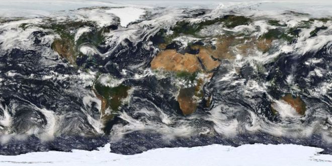
NASA launched the Earth Observing System's flagship satellite "Terra," named for Earth, on December 18, 1999. Terra has been collecting data about Earth's changing climate. On February 24, 2000, sensors on NASA's Terra satellite began opening their shutters and making their first observations. The mission ushered in a decade of observations from NASA's Earth Observing System, a coordinated series of satellites that monitor how Earth is changing.
This image is based largely on observations from the Moderate Resolution Imaging Spectroradiometer (MODIS) - a sensor aboard the Terra Satellite - on July 11, 2005. Small gaps in MODIS' coverage between overpasses, as well as Antarctica (which is in polar darkness in July), have been filled in using GOES weather satellites and the latest version of the NASA Blue Marble.)
A new book released this week highlights how the view from space with Earth-orbiting sensors is being used to protect some of the world’s most interesting, changing, and threatened places. From space, Egmont National Park in New Zealand shows the benefits and limitations of protected areas. In this Landsat 8 image acquired on July 3, 2014, the park, with Mt. Taranaki at its center, was established in 1900. This isolated island of protected forest (dark green areas) is surrounded by once-forested pasturelands (light and brown green).
“Sanctuary: Exploring the World’s Protected Areas from Space,” published by the Institute for Global Environmental Strategies (Arlington, Virginia) with support from NASA, debuted at the 2014 World Parks Congress in Sydney, Australia. In the book’s foreword, NASA Administrator Charles Bolden writes, “NASA and numerous other space agency partners from around the globe have used this view from space to make incredible scientific advances in our understanding of how our planet works. As a result, we can now better gauge the impact of human activity on our environment and measure how and why our atmosphere, oceans, and land are changing. As a former astronaut who has looked upon our beautiful planet from space, I hope that we can advance the use of space-based remote sensing and other geospatial tools to study, understand, and improve the management of the world’s parks and protected areas as well as the precious biodiversity that thrives within their borders.”
14. Earth’s Vital Signs
NASA launched the Earth Observing System's flagship satellite "Terra," named for Earth, on December 18, 1999. Terra has been collecting data about Earth's changing climate. On February 24, 2000, sensors on NASA's Terra satellite began opening their shutters and making their first observations. The mission ushered in a decade of observations from NASA's Earth Observing System, a coordinated series of satellites that monitor how Earth is changing.
This image is based largely on observations from the Moderate Resolution Imaging Spectroradiometer (MODIS) - a sensor aboard the Terra Satellite - on July 11, 2005. Small gaps in MODIS' coverage between overpasses, as well as Antarctica (which is in polar darkness in July), have been filled in using GOES weather satellites and the latest version of the NASA Blue Marble.)